Riyadh, the capital of Saudi Arabia, has undergone rapid urbanisation, with significant changes in its urban form. The city’s skyline is marked by high-rise buildings and sprawling low-rise developments. The average building height in Riyadh is relatively low compared to global standards for major cities (Mashary 2013). This has led to an urban form characterised by extensive horizontal expansion rather than vertical growth.

The city’s central business district (CBD) features iconic skyscrapers like the Kingdom Centre and Al Faisaliyah Center, symbolizing modernity and economic progress. However, these high-rise structures are exceptions rather than the norm. Most of Riyadh’s urban area consists of low-density residential neighborhoods with single-family homes, contributing to urban sprawl.
What describes Riyadh’s buildings height and how does low-density housing impact urban planning and other concerns? And is high-density a solution for Riyadh City?
Impact of Low-Density Single-Use Housing
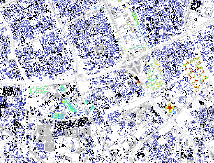
While the typical 2x2km2 neighbourhoods are relevant, the historic centre around Muraba, Batha and the first Salman Park with it vernacular urban form exhibits even lower buildings.
Low-density development, while often seen as a hallmark of suburban expansion, presents numerous challenges across environmental, infrastructural, social, and land use dimensions. The sustainability of such development is questionable and the inefficiency of infrastructure and public services with dispersed housing necessitates longer networks. Socially and economically, low-density, single-use housing fosters segregation which in turn dampens social interactions and urban vibrancy crucial for economic and cultural vitality. Furthermore, the inefficient land use inherent in such developments contributes to urban sprawl posing long-term sustainability concerns.
- Sustainability Concerns: Low-density development often increases energy consumption and carbon emissions. The sprawling cities require more extensive transportation, utilities, and services infrastructure, leading to higher per capita resource consumption (Aina et al. 2017). In Riyadh, the reliance on private vehicles is exacerbated by the lack of public transportation options, contributing to traffic congestion and air pollution.
- Infrastructure and Public Services: Providing infrastructure and public services in low-density areas is less efficient and more costly. The dispersed nature of housing requires longer networks of roads, water supply lines, and sewage systems. The cost of providing public services, such as waste collection and emergency services, is significantly higher in low-density areas compared to high-density urban cores (Mukherji, 2003).
- Social and Economic Impacts: Low-density, single-use housing often leads to social segregation and limited access to amenities. In Riyadh, many residential neighborhoods lack proximity to schools, healthcare facilities, and commercial areas, necessitating long commutes. This urban form can limit social interactions and reduce the vibrancy of urban life, which is crucial for economic dynamism and cultural exchange.
- Land Use Efficiency: The inefficient use of land in low-density developments contributes to urban sprawl and the loss of valuable open spaces. Riyadh’s urban growth has consumed vast tracts of land, encroaching on desert landscapes and agricultural areas. This pattern of development is unsustainable in the long term, given the finite nature of land resources.
Only the central area along with recent development (financial city, stadium) exhibit low building height of about two stories.
The Need for High-Density Mixed-Use Development
To address the challenges posed by low-density, single-use housing, Riyadh must embrace high-density, mixed-use development. This approach involves increasing building heights and integrating residential, commercial, and recreational spaces within the same urban area. The benefits of such a strategy are manifold:
- Enhanced Sustainability: High-density development reduces the need for extensive infrastructure, lowers energy consumption, and promotes the use of public transportation. Mixed-use areas encourage walking and cycling, thereby decreasing reliance on private vehicles and reducing carbon emissions.
- Improved Public Services: Concentrating population density in urban cores allows for more efficient delivery of public services and infrastructure. It enables economies of scale in waste management, water supply, and emergency services.
- Vibrant Urban Life: Mixed-use developments foster social interaction and economic activity. They create lively neighborhoods with diverse amenities, enhancing the quality of life for residents. Access to shops, restaurants, parks, and cultural facilities within walking distance enriches urban living.
- Efficient Land Use: High-density, mixed-use development optimizes land use, preserving open spaces and minimizing urban sprawl. It allows for the creation of green spaces and recreational areas within the city, contributing to environmental sustainability and residents’ well-being.
Riyadh’s urban strategic planning must prioritise increasing density and promoting mixed-use development to create a sustainable and vibrant urban environment. The current prevalence of low-density, single-use housing poses significant challenges regarding sustainability, infrastructure efficiency, and quality of life. By embracing high-density, mixed-use development, Riyadh can enhance its urban form, reduce environmental impacts, and foster a dynamic and inclusive cityscape.
Power of data
Platforms such as CGTrader offers a variety of 3D models related to a range of cities globally, including architectural structures, cityscapes, and notable landmarks. These models are suitable for research, animation, games, and VR/AR projects. The models are available in multiple file formats like FBX, OBJ, MAX, and C4D, and can easily be handled in Blender, sketchup and similar tools. For the grid based assessment above we transformed an OBJ file to a raster in Python:
import numpy as np
import matplotlib.pyplot as plt

def load_obj(file_path):
    vertices = []
    faces = []

    with open(file_path, 'r') as file:
        for line in file:
            if line.startswith('v '):
                vertices.append(list(map(float, line.strip().split()[1:4])))
            elif line.startswith('f '):
                face = line.strip().split()[1:4]
                face = [int(idx.split('/')[0]) - 1 for idx in face]  # OBJ indices are 1-based
                faces.append(face)

    return np.array(vertices), np.array(faces)

def calculate_grid_average_heights(vertices, cell_size=20):
    min_x, min_y = np.min(vertices[:, 0]), np.min(vertices[:, 1])
    max_x, max_y = np.max(vertices[:, 0]), np.max(vertices[:, 1])

    grid_x = int((max_x - min_x) / cell_size) + 1
    grid_y = int((max_y - min_y) / cell_size) + 1

    height_grid = np.zeros((grid_y, grid_x))
    count_grid = np.zeros((grid_y, grid_x))

    for vertex in vertices:
        x_idx = int((vertex[0] - min_x) / cell_size)
        y_idx = int((vertex[1] - min_y) / cell_size)
        height_grid[y_idx, x_idx] += vertex[2]
        count_grid[y_idx, x_idx] += 1

    avg_height_grid = np.divide(height_grid, count_grid, where=count_grid!=0)
    return avg_height_grid

def plot_height_map(avg_height_grid):
    plt.imshow(avg_height_grid, cmap='viridis', origin='lower')
    plt.colorbar(label='Average Height (m)')
    plt.xlabel('Grid X')
    plt.ylabel('Grid Y')
    plt.title('Average Height per 100x100m Cell')
    plt.show()

vertices, _ = load_obj(file_path)

avg_height_grid = calculate_grid_average_heights(vertices)
plot_height_map(avg_height_grid)
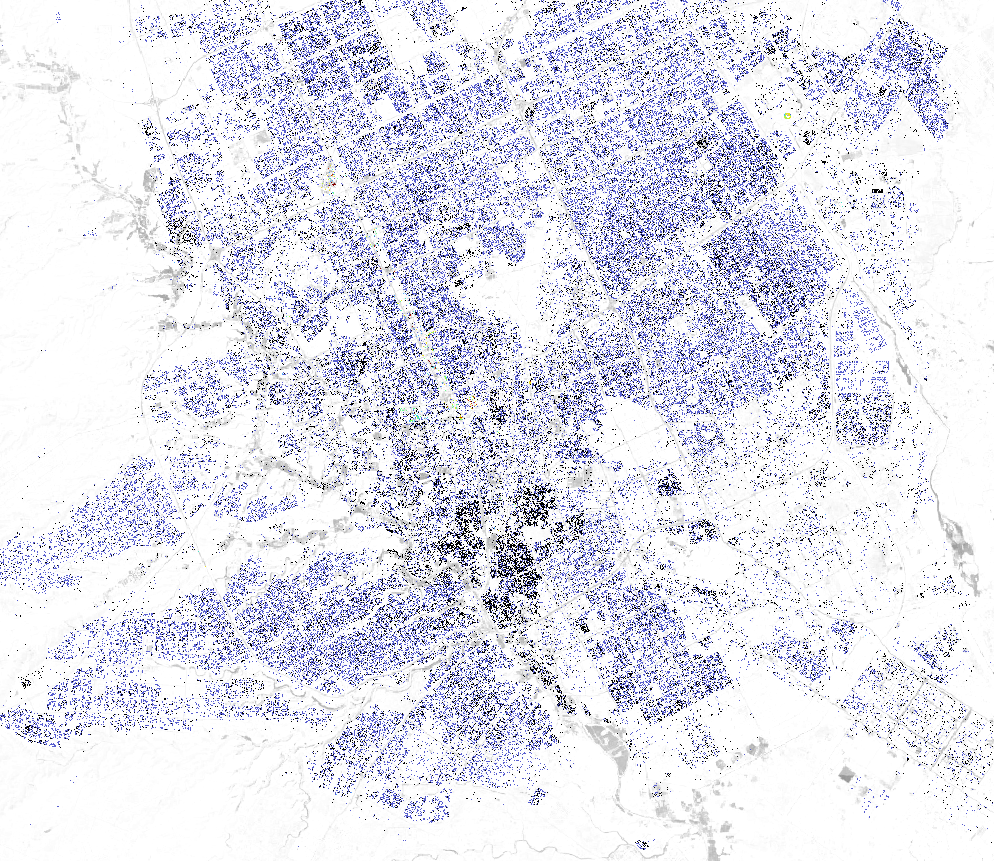
Building Heights per District

The difference between neighbourhoods of this large scale exercise is neglectable. Districts with large open areas have lower mean values. However, we witness that more recent development exhibit similar building heights compared to historic ones. Darker colours represent larger values for buildings.
The potential
The produced buildings height raster can be used in a wide variety of domains.
- We can produce statistics for height percentage variations across a certain area to advise authorities on land use planning and zoning regarding zoning regulations and development intensity.
- Evaluate solar energy potential from shadow patterns across the city, wind flow, and heat island effect analyses through studies on the effects of building height on wind flow patterns and heat island effect through the distribution of tall buildings and their contribution to temperature variations.
- Analyse the real estate market for property valuation and market analysis for real estate strategies.
- Study telecommunications and signal propagation and antenna placement.
- Protect historical sites and tourism development.
- Different geospatial analyses and 3d modelling, such as spatial pattern recognition and viewshed analyses, can be used.
- Analyse skyline to support urban skyline and visual aesthetics
- for disaster risk management and emergency response, evacuation planning requires the identification of high-rise buildings and population density estimations.
- Other usages include, but are not limited to, security, surveillance, transportation, and traffic management.
References
- A., Al Naim Mashary. 2013. “Urban Transformation in the City of Riyadh: A Study of Plural Urban Identity.” Open House International 38 (4): 70–79.
- Aina, Y. A., E. M. Adam, and F. Ahmed. 2017. “Spatiotemporal Variations in the Impacts of Urban Land Use Types on Urban Heat Island Effects: The Case of Riyadh, Saudi Arabia.” ISPRS – International Archives of the Photogrammetry Remote Sensing and Spatial Information Sciences XLII-3/W2 (November): 9–14.
- Burchell, Robert W., and Sahan Mukherji. 2003. “Conventional Development versus Managed Growth: The Costs of Sprawl.” American Journal of Public Health 93 (9): 1534–40.
Cover borrowed from Françoise Beauguion, a Canadian self-taught artist and graphic designer, Jazzberry Blue, works on questions of space and world representations in an abstract yet figurative manner. Through geometric and colorful approaches, he explores the subjectivity and simplicity of different forms of representation. https://www.jazzberryblue.com/
Make a one-time donation
Make a monthly donation
Make a yearly donation
Choose an amount
Or enter a custom amount
Your contribution is appreciated.
Your contribution is appreciated.
Your contribution is appreciated.
DonateDonate monthlyDonate yearly
Leave a comment